Friday, January 24, 2020

Machu Picchu, Peru

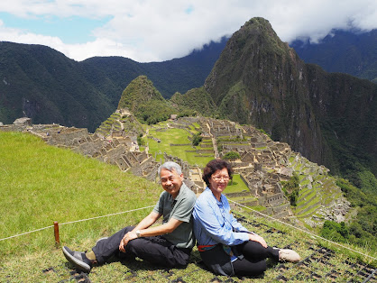
We finally made it to Machu Picchu at approx. 10.30am on 17 December 2019. At that moment, we had probably the same feeling as Hiram Bingham when he was led to rediscover this mysterious "Lost City of the Inca" deep in the jungle on top of the mountains in Peru on 24 June 1911. Soon after, serious investigation, study of the ruins and analysis of the relics and artifacts commenced. Two years later and through the National Geographic, Machu Picchu was brought to the attention of the world. Ever since then, its enigma has become the fascination and imagination of many adventurers, trekkers, thrill seekers and travelers just like us. In 1983, this site was declared a UNESCO World Heritage Site. In 2007, it was voted as one of the New Seven Wonders of the World.

Machu Picchu which means "Old Mountain" in Quechua language is reckoned to be built around the 15th century. It was abandoned just 30 years later. This Inca citadel built high in the Andes Mountains above the Urubamba River valley is the tangible evidence of the reign, sophistication and achievement of the Inca Empire. 
Machu Picchu as seen on 17 December 2019.
An illustration of the original Machu Picchu in the book
entitled "Presenting Machu Picchu"
by Saydi M Negron Romero.
14 out of 32 made it to the upper level of the complex.
********************************************
It is still a mystery why this ridge of the mountain was chosen for the construction of a citadel consisting of palaces, temples, plazas and dwelling houses. Certainly, the location is ideal for the elites who wanted a safe haven with year round awesome panoramic view surrounding the hideout! It's surrounded on three sides by Urubamba River at the valley below and sheltered by an imposing peak at the north.
As an engineer, it is the construction of this whole complex that is most remarkable and intriguing. With primitive hand held bronze tools, the builders were able to create ramps and terraces, erect buildings and walls that blend well with the contours of the steep mountainous terrain. The erosion free and stable platforms and terraces with preserved soil that promoted agriculture is testament of the Inca's skill in building and managing surface water drainage, irrigation and water conveyance system.
An entrance gate to Machu Picchu City.
Remnants of the pitched-roof dwelling houses.
Typical reconstructed pitched roof house.
Equally intriguing is the construction of the sophisticated dry stone walls that fuse huge blocks of stone without the use of mortar. The huge block stones fit so tightly together so well that the cracks cannot be penetrated by a knife blade. This is quite unlike the Great Wall of China in which mortar was used to fuse the bricks together.
**********************************************
Llamas, natives to South America and their cousin, the alpacas are still residents in Machu Picchu. These animals were kept during the Inca Empire for the meat and wool. Today, restaurants in Peru serve llama and alpaca meat. We were also ushered to outlet that markets sweaters, coats, blankets, cardigans and socks made from alpaca wool.
At the Sacred Rock called Wank'a in Quechua in the lower part of Machu Picchu Complex. It's surrounded by a small low wall.

Thursday, January 23, 2020

Maras Salt Pans & Moray: A UFO Landing Site in Peru?

Peru is blessed with another natural phenomenon - Salt Pans in Maras, one of the Inca ruins in Peru.  Our visit to this salt pans or salt mines is what I called an "acclimatization" tour to the Sacred Valley prior to our visit to Machu Picchu.

As our bus approached the valley, we were confronted with this jaw dropping view of the glittering pools and a myriad of  salt crusted terraces nestle against the sides of the mountains.

While we are familiar with the abstraction of sea salt from the sea water, salt extraction from this mines is similar except that the salt water or brine is natural stream that trickles down from the mountains. This salt from this mines is reckoned to be among the best in the world in view of the other minerals the brine contains.

This salt extraction started way before the Inca times and is still surviving to these days. Each of the thousands of ponds is sized between 4 to 10 square meters and 10 to 30 cm deep. Once the salt water evaporates, salt crystals formed are harvested with simple tools. Hence, they are more appropriately being referred to as salt evaporation ponds or pans rather than mines.

Each pond is owned by the local natives of the Maras Peru community who have exclusive right to harvest and sell.

It is truly remarkable to witness first hand this traditional salt abstraction method deep in the mountains at elevation over 3,000 m above sea level and inherited since over 1,000 years ago!
This google map is probably a better visual
of the topography of the salt ponds.
*************************************************
Earlier before we visited the Maras Salt Ponds, we were driven to see the Moray, another Inca ruin within the Maras area. These archaeological sites are terraced circular depressions built at the high plateau of elevation 3,500 m AMSL. Other than taking a few photos of one of the terraced circular depressions, we could not get to see much as it was a touch-and-go visit.

On the purpose of these depressions, the widely accepted explanation is that these bowl shaped depressions (deepest is 30 m) were once Incans agricultural laboratory. Because of the different conditions at each terrace and varying temperatures from the top to the bottom, it is believed that Incas used different levels to test and experiment with the crops and vegetation.

Not everyone buys this idea, because of its amphitheater-liked design, some hold the view that this was a place for ceremonies and celebrations for the Incas. 

Yet there is another more far-fetched absurd idea: These are sites for the landings of the terrestrial beings or the UFO's! This idea was reinforced by the "sightings" of UFO`s in the area!
An abstract from google map.

Wednesday, January 22, 2020

The Sacred Valley, Peru

The train route from Ollantaytambo to Aguas Calientes has made it so much more easier to visit Machu Picchu especially for the seniors like us.

Visitors to Machu Picchu normally start the trip from Cusco upon flying in from Lima. From Cusco, the old capital of Peru, it's on road by bus to Ollantaytambo. From Ollantaytambo, it's another one hour 40 minutes train ride to Aguas Calientes. And finally, an uphill ride in a smaller bus to Machu Picchu. 
To build a vehicular access road of 9 Km length over a 400m climb from Aguas Calientes to Machu Picchu, the final stretch has to zig zag intensely across many hair pins over the steep side of the mountain.
**********************************************
The train ride from Ollantaytambo to Aguas Calientes was another pleasant experience. Since the track is built running alongside the river bank of Urubamba River at the bottom of one of the Sacred Valley, passengers were able to enjoy the awesome views of the magnificent landscape and part of the Andean mountains range on either side of the river. The train ride was comfortable with free coffee and snack provided along the way.
**********************************************
We flew in from Lima the day before we were scheduled to visit Machu Picchu. By the time we landed in Cusco Airport, it's past noon and the rest of the day after lunch was spent on an "acclimatization" tour of the Sacred Valley. Cusco is situated at an elevation of 3,350m AMSL and is much higher than Machu Picchu at 2,400m AMSL. Some among the group who are not accustomed to high altitude and thin air started to feel uneasy and and were down with dizziness.

While some vomited in the bus because of altitude sickness, I was one of those who could continue enjoying the magnificent landscape and snow-capped mountains of the Andes along the way.

Tuesday, January 21, 2020

Tour of South America

A tour of South America has not crossed my mind until a friend talked about a 30-Day 6-Nation South America Cruise & Land Tour. After reading the book, "101 Things You Should Do before Going to Heaven", there seemed to be urgency to visit SA to see some of the wonders of the world on the other side of the globe. SA has both man-made wonders like Machu Picchu in Peru and Christ the Redeemer in Brazil as well as natural wonder like the Iguazu Waterfalls.

We decided to sign up for the SA Tour basically to see first hand some of these exotic places and wonders.

This 30-Day tour with a tour company was the longest we have had so far. In the end, it was not as rewarding as we had expected simply because it's a touch-and-go experience. Ten minutes here, 30 minutes there etc are just too short a time to see, feel and enjoy the ambiance of the place.

We also failed to see two of the places that were promised in the itinerary.  Puerto Madyn in Argentina and Cape Horn.  A delay to leave the port in Stanley, Falkland Islands due to some unexplained reason caused the Captain to skip Puerto Madyn and instead sailed straight to Montevideo, Uruguay.

Having visited Cape of Good Hope in the African Continent in 2013 (Read here), I was really looking forward to cross Cape Horn scheduled on 29 December 2019. In that morning of 29 December, the Captain simply announced that the ship would not be sailing to Cape Horn because of forecast big waves said to be 3.8m high. That miss has really been a great disappointment to many of the travelers in the ship!

Still, the tour was a wonderful experience of learning about new cultures and people, eating some of the highly recommended dishes and cuisines and making new friends!

Before the trip, I had little knowledge of the geography of SA. This trip to some extent has been a lesson on geography, history, people and culture of this huge continent.